Laser scanning is becoming an essential part of modern mapping technology. Laser scanning is a remote sensing method, which utilizes leaser beams for gathering spatial data and acquiring finer details. A laser scanner is a very flexible surveying instrument – it can be mounted on a static tripod (terrestrial laser scanning –TLS), an aircraft (airborne laser scanning – ALS) or a mobile ground platform (mobile laser scanning – MLS).
The latter, i.e. mobile laser scanning, allows measurements to be taken e.g. in a moving vehicle, thus making it significantly more flexible and operational compared to the conventional “static” surveying methods, allowing, if necessary, data to be collected on road width, curb heights, location of traffic signs, road markings, etc.
Recently Kalev Julge defended his doctoral thesis “Laser Scanning of Built Environment and Landforms with Spatial Modelling Applications” at the TTÜ Department of Civil Engineering and Architecture.
“The goal of the doctoral thesis was to analyse different laser scanning technologies and optimise modelling of the spatial data gathered. We divided this process into three stages: assembling a compact, low-cost prototype MLS system and developing a methodology for calibration; analysing the effectiveness of ground filtering algorithms; optimal use of different LS technologies in conjunction with one another,” the supervisor of the doctoral thesis, Professor at the TTÜ School of Engineering Artu Ellmann says.
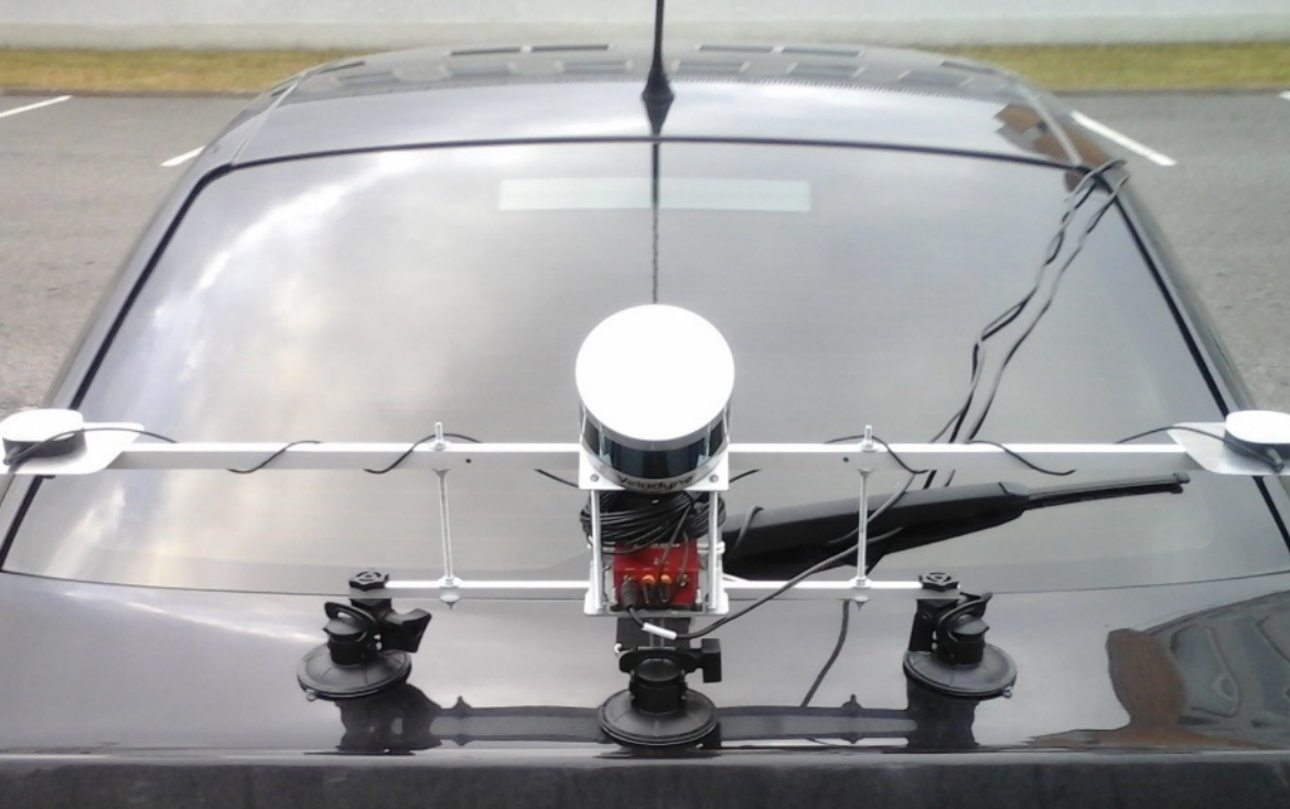
The main task was to construct a compact easily mountable prototype MLS system. The objective was to assemble a system, which can be conveniently transported e.g. in hand luggage and easily mounted on a locally available platform (a rental car). These factors are a major advantage over current commercially manufactured expensive MLS systems that need to be mounted on a stationary platform.
In the course of preparation of the doctoral thesis the new prototype MLS system was tested on a car and a backpack. The accuracy of the MLS system was evaluated by comparing the results obtained with high-accuracy static terrestrial laser scanning (TLS) data and the vertical, horizontal and relative accuracy were determined to be 8 cm, 15 cm and 3 cm. The achieved mapping-grade accuracy shows that this relatively compact MLS system, which is considerably less expensive compared to the systems used so far, can be successfully used for surveying terrain, buildings, roads and other engineering structures.
Professor Ellmann says: “The studies proved that the developed technology can be successfully used for scanning various built environments and landforms. Laser scanning has become accessible to a wider userbase due to advanced and inexpensive equipment, combined use of the technologies and introduction of freeware software.”
The new prototype MLS system was developed in collaboration with the surveying industry partner Reach-U AS.
The supervisor of the doctoral thesis was Professor Artu Ellmann (TTÜ).
The opponents were Antero Kukko (National Land Survey of Finland, Aalto University) and Associate Professor Milan Horemuž (KTH Royal Institute of Technology).
The doctoral thesis is available at https://digi.lib.ttu.ee/i/?9288
Additional information: Professor Artu Ellmann, artu.ellmann@ttu.ee