Recently Tarvo Mill defended his doctoral thesis “Application of Terrestrial Laser Scanning Technology for Engineering Structure Surveys” at TTÜ Department of Civil Engineering and Architecture.
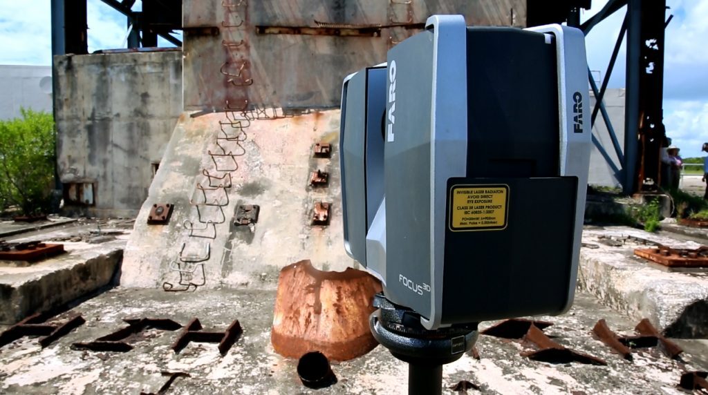
Terrestrial laser scanning technology (TLS) has been used in the field of geodesy already for over two decades. This technology is applied to rapidly and accurately record various spacial relations of buildings, roads and technical facilities, but also landscape topography. Due to the highly detailed spatial data laser scanning is currently widely used in the construction industry and property management services (e.g., when evaluating the state of a site, etc.), but it can also be used e.g. in criminalistics to document the spatial connections of crime scenes.
TLS data (MITMUS!) are usually used to create a 3D digital model, for example, a building information model (i.e., BIM), which makes it possible to improve the management of the object, perform various simulations, make design improvements, etc. The scanning data make it possible to design in an existing detailed 3D in-built and natural environment. The design work can take place directly in the 3D virtual reality, which helps to avoid possible mistakes and gives a good overview of the positioning, appearance and the functioning of the object components (e.g. a construction element).
The supervisor of the doctoral thesis, Professor at the School of Engineering Artu Ellmann says, “The main objective of this doctoral thesis was to investigate TLS applications for engineering structure surveys. In particular, the aim was to develop a methodology for estimating measurement uncertainty (the range within which the true value lies) of laser scanning.
The methodology developed in the doctoral thesis deals with the calculation of measurement uncertainties in the along-normal direction of the surface. “The smaller the measurement uncertainty (i.e. measurement error), the closer the measurement results are to the actual location of the surface and the more accurate the resulting geometrical model of the surveyed object or construction element will be, ” Professor Ellmann explains. It was concluded that the derived calculation method is the most optimal way to estimate the expected measurement uncertainties. The method is useful when planning surveying projects that require high accuracy (e.g. analysis of deformations of structural elements). The derived method was successfully verified in a destructive load test of a highway bridge and when investigating frost heave of roads.
Professor Ellmann says, “The method is also useful in geodetic surveying, where measurement accuracy is estimated both before and after the surveys. By knowing the probable accuracy of a survey, it is possible to make changes in the work procedures, check the equipment and instruments, etc. when planning surveying projects, to increase the expected accuracy. After the surveying, the results of the accuracy estimates are also used in the post-processing stages (to eliminate errors, etc.). Post-estimation of accuracy is also necessary to prove the conformity of the surveys to requirements.
Terrestrial laser scanning can be considered to be one of the fastest developing technologies in geodesy. Scanning devices are becoming faster (data acquisition rates reach over a million points per second), more accurate, and easier to use thanks to smart applications (colour touchscreens, remote control using smart phones, internet connectivity, etc.). “The rapid progression of the technology and constant increase in efficiency has already created an unlimited number of possibilities for using TLS technology not only in the construction industry, but also in other areas of engineering,” Professor Ellmann says.
The supervisor of the doctoral thesis was Professor at the School of Engineering Artu Ellmann.
The opponents of the doctoral thesis were Professor Thomas A. Wunderlich (Technical University of Munich) and Associate Professor Jānis Kaminskis ( Riga Technical University).
The doctoral thesis (author Tarvo Mill) is available at the following link: https://digi.lib.ttu.ee/i/?9118
Additional information: Professor Artu Ellmann, artu.ellmann@ttu.ee