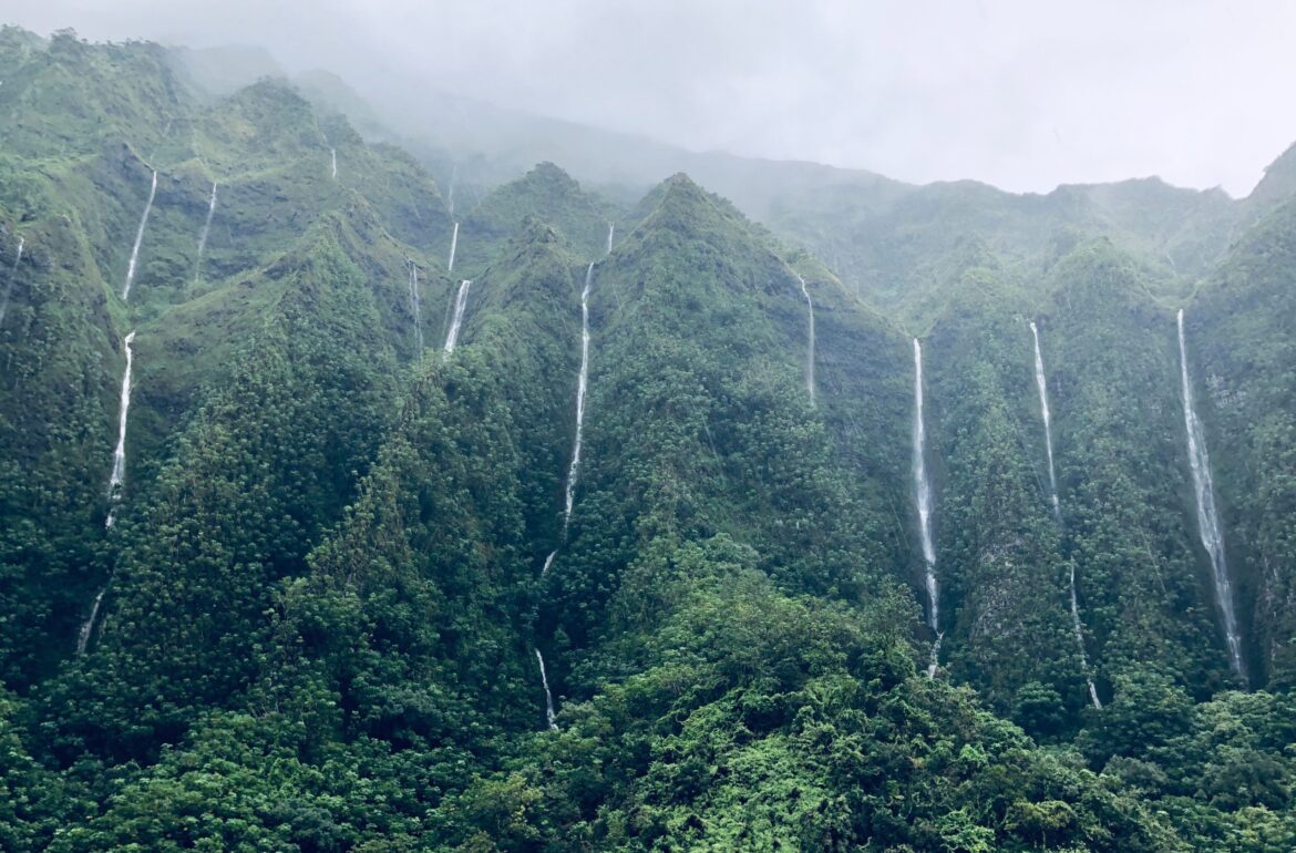
Brazil houses more than half of the Amazon rainforest (>5 Million km²) in South America. Though, since 1988 until 2019, an area of approximately 9 times the Estonia territory (446 019 km²) of the Brazilian primary rainforest has been deforested. Recently published study in Scientific Reports by University of Tartu scientists identified increasing fragmentation of forest cover in the Brazil’s Legal Amazon.
Cattle farming and soybean production have been important drivers of deforestation in Amazon. During the last 15 years, Brazil has tried to reduce the deforestation by implementing several action plans. In 2004, Brazil launched the Action Plan for Deforestation Prevention and Control in the Legal Amazon (PPCDAm) aiming to reduce the deforestation and promote sustainable development in the Amazon region. Along with this plan, in the following years, two other initiatives summed efforts to fight deforestation. In 2006 and 2009, the Soy and the Beef Moratorium initiatives were respectively created.
Based on data from the national deforestation monitoring system (PRODES) provided by Brazil’s Instituto Nacional de Pesquisas Espaciais, the PPCDAm and the Moratorium programs have been able to reduce deforestation but not to stop and illegal deforestation is still a problem. For example, recent study by Rajão et. al. published in Science estimated that approximately 20% of soy exports and at least 17% of beef exports from Amazon and Cerrado biomes to the European Union may be contaminated with illegal deforestation. This indicates how serious illegal deforestation in the Amazon can be.
Using satellite images, PRODES has been monitoring deforestation in primary forest in the Brazil’s Legal Amazon and providing annual reports since 1988. Although PRODES data is crucial for monitoring deforestation rates, it provides an incomplete picture of the dynamics of the deforestation process for the whole Brazil’s Legal Amazon. For instance, PRODES defines deforestation as complete removal of the primary forest (dense tropical forest), but excludes other forest types (i.e., secondary forest, savannah, shrubland) and other forest disturbance dynamics (e.g., illegal selective logging and fire), and it does not consider deforestation of areas smaller than 6.25 ha.
To overcome this shortcoming, geographers at University of Tartu used global high-resolution (30-m) Global Forest Change data developed based on Landsat images by research team in Maryland University to estimate the deforestation and forest fragmentation trends in the Amazon from 2001 to 2017. The dataset maps the forest loss caused by any type of disturbance, including fire, logging, loss of secondary forest, and small-scale forest loss (to a minimum area of 0.09 ha). Using this dataset, they identified how much deforestation occurred from 2001 to 2017 and how many new forest fragments were created every year.
They found that even though the deforestation has indeed decreased from approximately 30 million hectares in 2004 to approximately 15 million hectares in 2015, the number of new forest fragments increased after 2010 despite the low rates of deforestation. This is mainly because the deforestation process has shifted from the borders of the forest to inner areas of the region and the deforestation is more fragmented (large number of smaller patches). It means that now the deforestation is occurring in the areas that were considered isolated before. To reach these inner areas, infrastructure is being built which creates additional new forest fragments. It was also observed that the deforested areas became smaller, decreasing about 44% in size from 2000 to 2017. One explanation for it is that the landowners (or illegal loggers) are trying to avoid being spotted by the monitoring system that is used to coordinate field inspections to apply the fines or arrests is case of illegal logging. In addition, the observed increase in the deforestation rates in 2016 and 2017 is partially related to the occurrence of fires. The occurrence of fire in the Amazon is usually related to its use during the deforestation process or for agricultural and pasture management. In some cases, especially during drought periods, fires can escape the site being managed and become forest fires.
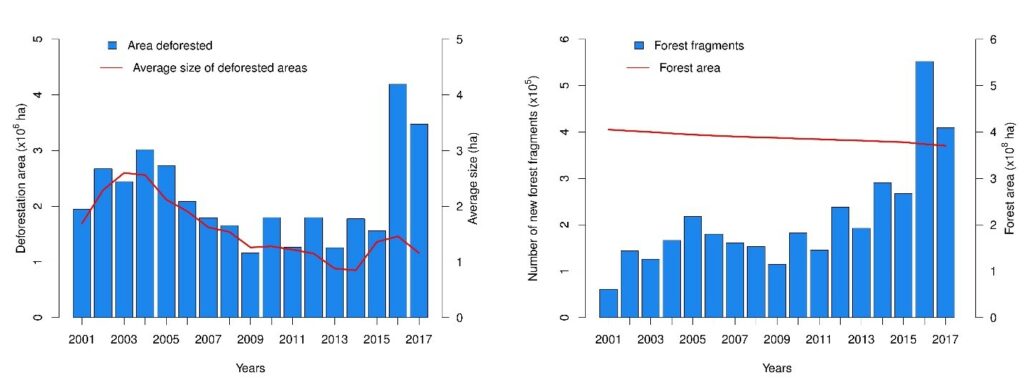
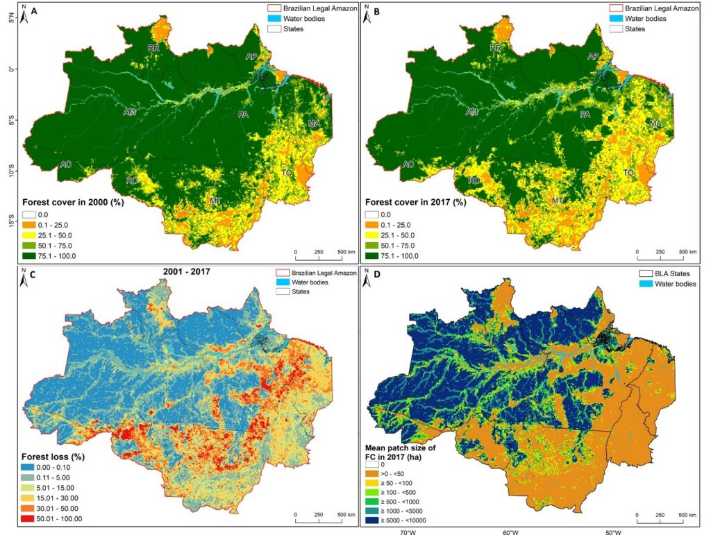
The analysis showed that the mean size of the remaining forest cover patches is decreasing over time, and this, combined with the increasing number of fragments, will have strong negative impacts on biodiversity, edge effects and susceptibility to fire. It also boosts carbon emission. Negative effects on biodiversity come from a reduction in the connectivity of the fragments, which is essential for species migration.
One key result of the study is that it revealed the increase of small-scale forest loss and of forest cover fragmentation. Reducing the minimum mapping area threshold of the current Brazilian monitoring systems (e.g. PRODES or near real-time deforestation detection-DETER) would be an important response to the new pattern of forest loss and improve the annual estimates of forest loss in the Amazon region.
However, this reduction would not result in a decrease of forest loss if the government provides insufficient financial and human resources to support field inspections and to punish the responsible. Moreover, it is important to consider the objectives of the monitoring systems, since the reduction of the minimum mapping area for instance, would be costly and would compromise comparisons of the monitoring time series. In addition, the observed increase in forest loss in 2016 and 2017 is disturbing given the current situation in Brazil, in which the government shows no intention to promote forest conservation.
Authors: Bruno Montibeller, Evelyn Uuemaa and Ülo Mander.
For further information:
Bruno Montibeller
+372 5893 3545
bruno.montibeller@ut.ee